Predictive
Risk Intelligence
AI-driven threat analysis that transforms multi-source intelligence into actionable risk scores, early warnings, and decision-ready outputs — across 30+ global maritime regions in real time.

Intelligence That Anticipates,
Not Just Reports
Multi-Source Intelligence Fusion
AIS vessel feeds, naval intelligence, coast guard data, and open-source streams normalized and correlated into a unified threat picture across 30+ monitored regions.
AI-Assisted Risk Scoring
ML models trained on historical threat data deliver automated risk scores with explainable outputs for every monitored region and vessel — updated continuously.
Predictive Early Warning
AI detects when a region is trending toward a higher risk tier before it officially escalates — providing 12–24 hours of actionable lead time for operators.
Five-Tier Risk Classification
Every monitored zone is classified L1 (Very High) through L5 (Very Low), enabling proportionate, calibrated responses at executive, operational, and tactical levels.
Custom Point Tracking
Define and monitor 100+ custom locations, vessels, or assets with configurable alert thresholds and automatic multi-channel push notifications on threshold breach.
Full Audit & Event Log
Every threat event, AI analysis, and analyst action is timestamped and logged with full context — providing forensic-grade records for compliance and post-incident review.
Five-Tier Risk Model
Every monitored maritime region and vessel is continuously scored against a structured five-tier model — calibrated from historical incident data, active intelligence feeds, and real-time threat indicators. AI models detect tier escalation 12–24 hours before it officially registers.

Gulf of Aden classified LEVEL 2 HIGH — system auto-notified subscribed shipping companies and coast guard liaisons in real time. Gulf of Guinea elevated to LEVEL 1 VERY HIGH during active piracy cycle.
Sea Guardian
A maritime SIEM — Security Information & Event Management — that ingests AIS, naval, and open-source feeds, runs AI correlation to surface anomalies, and delivers prioritized alerts to the right people within seconds of detection. Used by maritime security firms, shipping companies, and coast guard units.
Live visual overlay of 30+ threat zones, shipping lanes, and risk-rated regions on a global interactive map — updated continuously from multi-source feeds.
Historical and live analytics dashboards surface patterns, trends, and emerging risk hotspots across all monitored maritime areas.
Define and monitor 100+ custom vessels, ports, or regions. Configure individual alert thresholds per asset.
Multi-channel push notifications and escalation protocols fire within seconds of a threshold breach — reaching the right analyst immediately.
ML models correlate multi-source signals to deliver predictive risk scoring, anomaly detection, and early warning across all five risk tiers.
Commander, analyst, and operator tiers — each receiving the right intelligence for their role, with full audit trails on every action.
- Maritime security firms
- Shipping companies
- Coast guard units
- Government agencies

ArkadoAI Maritime Analysis
Describe a maritime security situation — in plain text or by uploading a file — and ArkadoAI returns structured intelligence in seconds: risk level classification, primary threat category, and a percentage breakdown across all threat types.
- Risk level classification (Very High → Very Low)
- Primary threat category identification
- Multi-category threat scoring breakdown
- Text input or file upload
- Seconds, not reports
Critical Infrastructure Command & Control
One command-and-control layer for utility and energy networks — power grid, gas, water, and beyond — fusing live camera feeds, sensor data, and GPS tracking into a single operational picture. Deployable across a broad range of critical-infrastructure environments.
For example — take a natural-gas distribution network:
Remote Physical Security Monitoring
A remote-monitoring platform for physical security at critical infrastructure sites — pipeline junctions, substations, pumping stations, treatment plants. Each monitored location streams live camera feeds and sensor data — leaks, flooding, door and access events — back to a central map of all sites, with instant alarms on any anomaly, including a site going silent.
Opening an alarm brings up a dedicated situation view for that location: a full camera mosaic alongside a live site layout showing exactly which sensor triggered, backed by rolling recorded footage so operators can jump straight to the moments before the alarm. Built to scale from a handful of pilot sites to a full nationwide network.
- Live camera feeds + sensor data per site
- Central map with instant anomaly alarms
- Dedicated situation view per alarm
- Rolling recorded footage · pre-alarm playback
- Scales from pilot sites to nationwide network
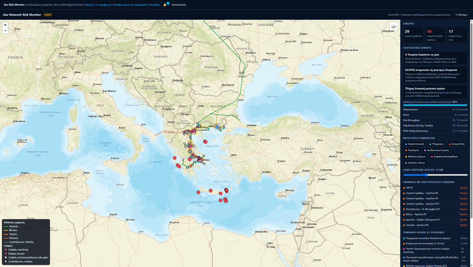
Gas Network Risk Monitor
A risk-assessment platform built for a national gas transmission network. It continuously ingests real-world events — severe weather, seismic activity, wildfires, civil unrest, geopolitical disruptions — and correlates them geographically with the pipeline network to compute live risk scores for every asset, pipeline section, and station.
An AI layer turns those scores into readable risk assessments and recommended actions, backed by a full incident-management and notification workflow that keeps response teams in the loop in real time. A built-in training module lets staff run realistic emergency drills on the same live map — fully isolated from production data — so teams can rehearse the real response workflow with zero risk to actual operations.
- Live, geo-correlated risk scores per asset
- AI-generated risk assessments + recommended actions
- Incident management & real-time notifications
- Isolated training mode for emergency drills
Deploy Sea Guardian for Your Operations
Discuss your coverage requirements, monitored regions, and alert configuration with our maritime intelligence team.